The Chindwin River(Myanmar)
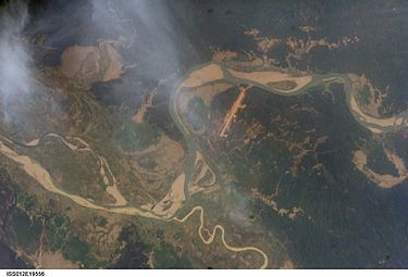
The Chindwin River, also known as the Ningthi River is a river flowing entirely in Myanmar, and the largest tributary of the country's main river, the Ayeyarwady.[5] Its official name is also spelled Chindwinn.[6]The Chindwin originates in the broad Hukawng Valley of Kachin State of Burma, roughly 26°26′18″N 96°33′32″E, where the Tanai, the Tabye, the Tawan, and the Taron (also known as Turong or Towang) rivers meet.The headwaters of the Tanai are at about 25°30′N 97°0′E on the Shwedaunggyi peak of the Kumon range, 12 miles (19 km) north of Mogaung. It flows due north for the first part until it reaches the Hukawng Valley. In 2004, the government established the world's largest tiger preserve in the Hukawng Valley, the Hukaung Valley Wildlife Sanctuary, with an area of approximately 6,500 km2 (2,500 sq mi); later, the Sanctuary was extended to 21,800 square kilometres (8,400 sq mi), making it the largest protected area in mainland Southeast Asia. The river then turns to the west and flows through the middle of the plain, joined by the Tabye, the Tawan, and the Taron rivers from the right bank. These rivers drain the mountain ranges to the north and northeast of the Hukawng valley.The Tanai exits the Hukawng valley through the Taron or Turong valley and through a sharp defile in the river. It then takes on the name of Chindwin, and maintains a general southerly course.[5] It passes the town of Singkaling Hkamti on the left bank, then the town of Homalin, also on the left bank.The course of river is generally southwesterly until the town of Mingin. It then takes a more southeasterly course entering into broad central plain, passing the city of Monywa on the left bank. Its course at this point forms the boundary between the Sagaing District of Sagaing Region and the Pakokku District of Magway Region.It enters the Ayeyarwady River (Irrawaddy) at about 21°30′N 95°15′E. The extreme outlets into the Ayeyarwady are about 22 miles (35 km) apart, the interval forming a succession of long, low, partially populated islands. The lowest mouth of the Chindwin is, according to tradition, an artificial channel, cut by one of the kings of Bagan (Pagan). It was choked up for centuries until 1824 when it was opened out by an exceptional flood.[7] Satellite pictures show this lowest channel to be the widest one today.Photo:Wikipedia