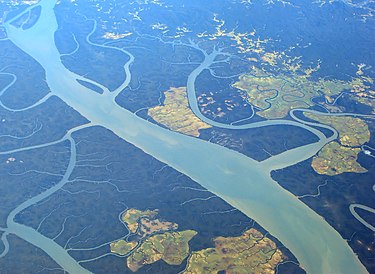
The Irrawaddy River(Myanmar)
The Irrawaddy River is a river that flows from north to south through Myanmar (Burma). It is the country's largest river and most important commercial waterway. Originating from the confluence of the N'mai and Mali rivers,[7] it flows relatively straight North-South before emptying through the Irrawaddy Delta in the Ayeyarwady Region into the Andaman Sea. Its drainage basin of about 404,200 square kilometres (156,100 sq mi) covers a large part of Burma. After Rudyard Kipling's poem, it is sometimes referred to as 'The Road to Mandalay'.As early as the sixth century, the river was used for trade and transport. Having developed an extensive network of irrigation canals, the river became important to the British Empire after it had colonized Burma. The river is still important today because it is used for a significant amount of traffic and (export) goods. In the Irrawaddy Delta, rice is grown using river water as an irrigation system.In 2007, Myanmar's military dictatorship signed an agreement for the construction of seven hydroelectric dams, yielding a total 13,360 MW, in the N'mai and Mali Rivers, including the 3600 MW Myitsone Dam at the confluence of both rivers. Environmental organisations have raised concerns about the ecological impacts on the river's biodiverse ecosystems. Animals potentially impacted include the endangered Irrawaddy dolphin and the critically endangered Ganges shark.Photo:Wikipedia